
While we had already been to the Yukon and Alaska in 2018 we wanted to retrace a few of our steps and fill in some of the missing pieces. On the previous journey we had flown into Whitehorse to start our exploration, but this time we wanted to drive the entire route from Vancouver including, of course, the famous Alaska Highway and the infamous Dempster Highway. The Alaska Highway, however, doesn't start until Dawson Creek so we decided to get there via a stop in Jasper and, managing to bypass all the wildfires, we headed up the Coquihalla/Yellowhead Highway in our rented Jeep. While most of the roads are paved, having a Jeep would prove to be invaluable when we came to roads that weren't.


Following the placid Thompson River that flows alongside the Yellowhead Highway, we arrived in the delightful tourist town of Jasper in time for dinner. The streets were packed, as were all the restaurants, but the mood was festive with everyone wanting to take a break from Covid though most were still wearing masks except the elk. The air was fresh and clear with no evidence of wildfires anywhere nearby.


The stunning beauty that surrounds Jasper is, of course, the reason 2.5 million tourists visit the National Park every year and this was the perfect place to start trying to absorb the majesty of the mountains and colourful terrain this part of the country has to offer. It's all so overwhelming that it actually becomes hard to appreciate but we gave it our best try.


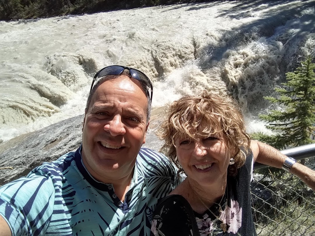
To avoid the hordes we were up early to hit the Skywalk, a dizzying glass bottomed walkway near the Icefield Centre. Offering incredible views of the surrounding peaks and Sunwapta River down below as you hang over a cliff is a test of engineering trust.


The Centre also offers tours to check out the rapidly disappearing glaciers that will be all melted within the next 50 years.


There were also the impressive Sunwapta and Athabasca Falls to check out while snapping pictures of ever changing mountain peaks in between.


There are many parts of Jasper National Park to explore and one of them is the Maligne Valley. As we drove along the road past the beautiful Medicine Lake we encountered a magnificent elk quite happy to pose for his photo.


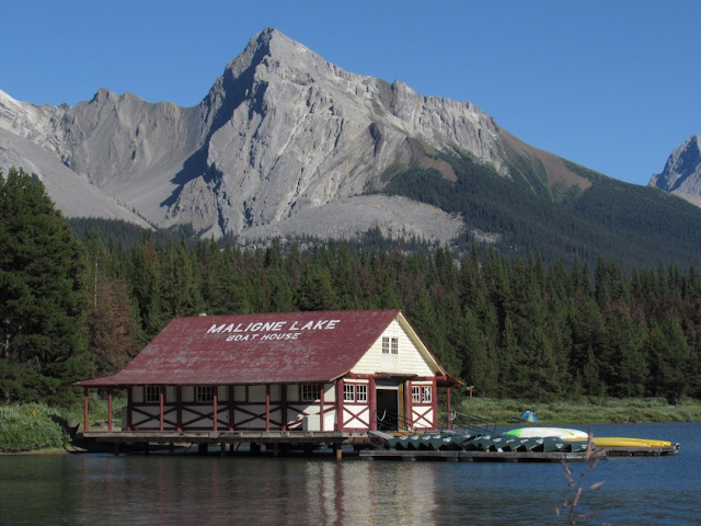
But it's when you reach Maligne Lake at the end of the road that you realize what a true postcard photo opportunity looks like. Here you can rent a canoe, go for a hike, or simply enjoy a nice meal overlooking the lake with the Valley of the Gods in the background.


Leaving Jasper we headed along the scenic route along Hwy. 40 towards Fort St. John. Just outside of Jasper we encountered some mountain goats and then enroute to Grande Cache we came across a black bear and her cubs.


Then as we were heading towards Grande Prairie we came across a grizzly bear just snacking on the vegetation beside the road.


Stopped in at the 41,000 square foot Philip J. Currie Dinosaur Museum in Wembley where an impressive display of locally excavated fossils from the Pipestone Creek bonebed can be viewed. The Pipestone Creek bonebed is considered one of the densest fossil sites in the world and include the first Pachyrhinosaurus discovered along with hadrosaurs, tyrannosaurs, plesiosaurs and pterosaurs. The museum also arranges weekly hands-on discovery tour hikes to Pipestone Creek.


There was also a display of local mammals that gave Junie a chance to measure up with a grizzly.

Enroute to the start of the Alaska Highway you pass the town of Beaverlodge with its giant statue.


At last we come to Dawson Creek, the start of the Alaska Highway which ends in Fairbanks, Alaska. Built in 1942 at the height of WW2 in order for the U.S. military to have access to Alaska, 10,000 U.S. Army Corps of Engineers, with hundreds of pieces of equipment, completed the job in less than 8 months. It was a work of amazing speed with 2,700 kilometres of highway constructed through forest and mud under challenging conditions that included extreme cold in winter and hordes of insects in summer.


As per the terms of the original agreement the U.S. had to pay for the construction of the highway but 6 months after the war ended the Canadian portion, which was over 2,200 kilometers, would be turned over to Canada. Over the years the highway has been rerouted and straightened in many sections with the result that it's now nearly 500 kilometers shorter. The Alaska highway has also been completely paved making for a safe and comfortable drive.


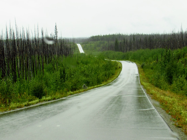
The first thing you notice about the Alaska Highway once you leave Fort St. John is that the road seems to go on forever and there's hardly any other traffic except the long haulers. No police either so it's up to you how fast you really want to go. Serving as both a firebreak and a way to minimize sudden animal collisions, the wide road shoulders are filled with colourful fireweed that keep inviting you to stop and photograph.


Stopping only to check out the rest areas at Duhu Lake and Andy Bailey Park we enjoyed a leisurely ride to Fort Nelson. Considered the real Mile 0 of the Alaska Highway since there was already a road from Fort St. John to Fort Nelson, the town was once a bustling service centre to the gas industry and local sawmills and is the hub between Yukon and Fort St. John. But with collapsing commodity prices it has fallen on hard times. Its principal attraction now is the colourful heritage museum.


Saying goodbye to Fort Nelson we got back on the Alaska Highway and quickly spotted some black bears. This stretch of road to Watson Lake would have some of the most dramatic scenery and have all sorts of wildlife. Going through Summit Lake and Muncho Lake Parks offered one breathtaking view of lakes and mountains after another and of course no photo could really do it all justice.


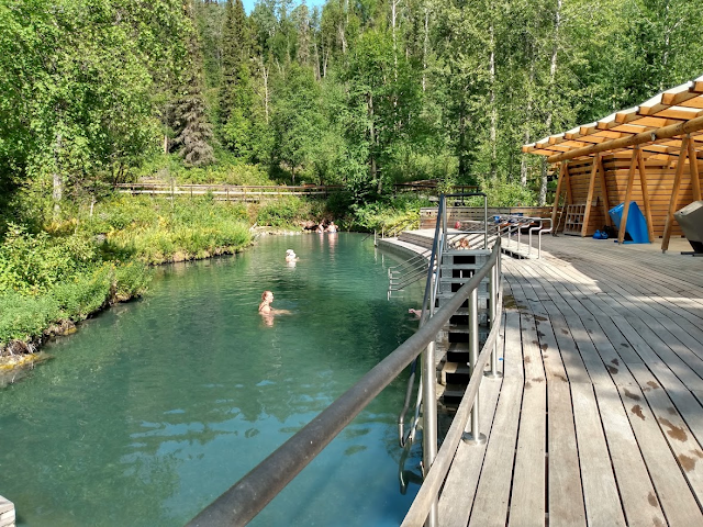
We stopped in at the Liard River hot springs, a fantastic facility in the middle of nowhere, and enjoyed a good soak and a nice rest from all the driving.


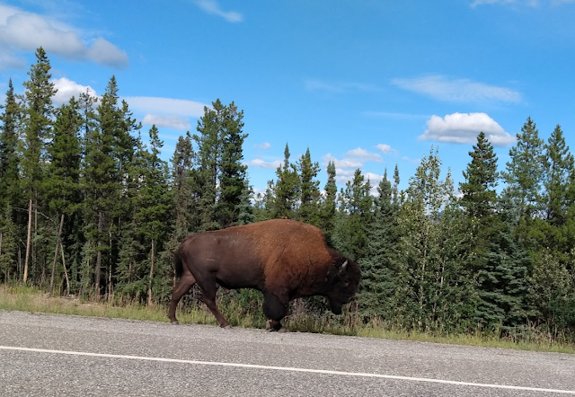
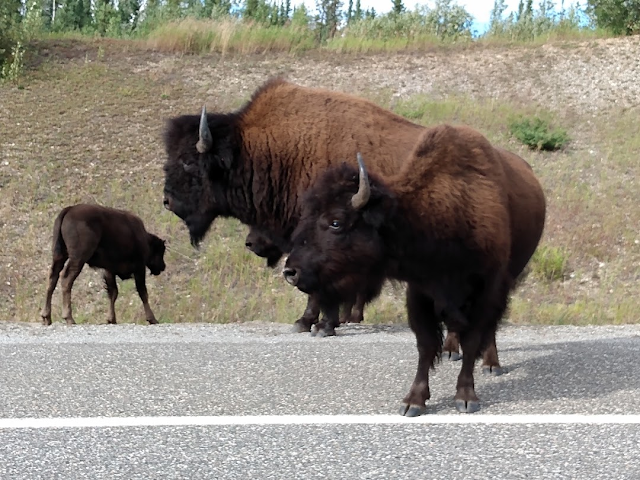
The warning signs for bison were the first indication we were in the territory of the Nordquist Wood Bison herd. A distinct herd that was established as part of the Wood Bison Recovery Program in the 1980's in the Northwest Territories, Alberta, British Columbia, and Yukon, there are now three different bison herds in Yukon, the Nahanni, the Aishihik, and the Nordquist. The wood bison, which are larger than the plains bison, are unique to Canada and their recovery has been so successful that limited hunting has even been instituted to manage their population.


In spite of being on the lookout for these magnificent beasts it was still a shock to encounter them as we went around the bend of the road and we felt like we had hit the jackpot. Careful to give them all the space they wanted, especially when a couple of males started banging heads and pushing each other around, we crept by not wanting to disturb the siesta they were having. Weighing up to 2,600 lbs. these guys can really do a lot of damage if they decide to take a run at your vehicle.


Shortly after our bison encounter we crossed the 60th parallel and entered into Yukon where we spent the night at Watson Lake, famous for its sign post forest. Started by a homesick soldier in 1942, it has now grown to over 80,000 signs from around the world. It also boasts a Northern Lights interpretive centre.


Next day it was back on the road having reached the halfway point on the Canadian portion of the Alaska Highway. With the rainy weather there wasn't much wildlife to checkout but there were other interesting sights along the way.


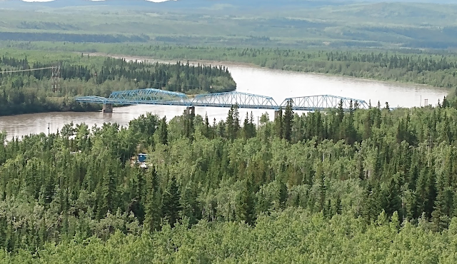
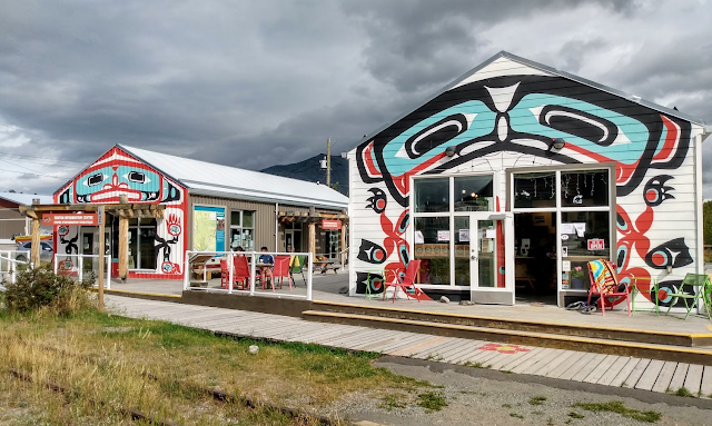
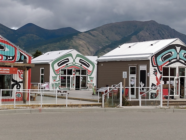
Crossing the Teslin Lake bridge we came into the Village of Teslin itself. Part of the Tlingit First Nations the Teslin are an inland people who have signed a land claim agreement and are self governing and self sustaining. Their strikingly designed heritage centre provides a showcase for modern and traditional arts and culture and includes a gift shop offering arts, crafts and other items.


There was a turn-off at Johnsons Crossing that offered an off road experience into the heart of Yukon but the skeletons of vehicles that had gone before convinced us to continue along the road we were on.


Temporarily by-passing Whitehorse, the capital city of Yukon, we continued down the highway to Haines Junction watching as the snow capped mountains of Kluane National Park came increasingly into view.


A lynx even came by to greet us while we were taking some pictures, a very rare sighting that we were lucky to capture.


Checked into our spectacular eco-lodge, located in the shadow of the St. Elias mountains just outside of Haines Junction, and were given a warm welcome by the owner's two dogs, Freya and Daisy.


Kluane National Park and Reserve is bordered by the Alaska Highway to the northwest and the Haines Highway to the southeast. On our first day we headed out on the Haines Highway, and our first place to stop for a pleasant stroll was the pretty Kathleen Lake.


Next on the list was Rock Glacier which gave us a little elevation and a nice view of Dezadeash Lake. It was also an interesting display of trail building with the way rocks had been placed in order to facilitate walking through the glacier debris.


It was also interesting to note the changes in vegetation as we climbed towards the Haines Highway Summit and were once again treated to some of the local wildlife.


Once the Alaska Highway had been completed in 1942 the U.S. Government decided an alternate access to the highway should be provided in case the White Pass Railway from Skagway was blocked. Once again the U.S. Army quickly built a rough road this time to connect Haines, Alaska with Haines Junction, Yukon. A very difficult road to maintain even to this day, it wasn't even opened year round until 1963 and because of all the snowstorms and mudslides a radio check system was installed to check every vehicle using the road.


The next day we were off in the other direction and once again had a pleasant warm up at the Spruce Beetle trail.


Then it was off to the Thechal Dhal Visitor Centre along the shore of Kluane Lake where they have colourful exhibits and sheep viewing scopes.


This is also the trailhead of the famous Soldiers Summit trail where a commemorative plaque marks the place where the road building crew from Alaska met up with the road building crew from Canada on November 20th 1942 and completed the Alaska Highway.


At the end of a long day of driving and hiking the most important thing is to find a good watering hole and fortunately the Mile 1016 Pub is perfectly situated at the junction of the Haines Road and the Alaska Highway otherwise known as Haines Junction. After all the straightening and upgrades to the highway the original Mile markers are hopelessly out of date but they still serve an historic purpose.


Kluane National Park and Reserve was established in 1972 and covers 8,500 square miles. It's also part of a bi-national park system that has been declared a UNESCO World Heritage Site. Kluane is home to 17 of Canada's highest 20 peaks including Mt. Logan, at 19,551 feet, the highest peak in Canada and 2nd highest in North America after Mt. Denali which is 20,310 ft. in elevation. 83% of the Park is covered in ice and mountains and the only practical way to get close to Mt. Logan and the icefields or glaciers is to book a sightseeing flight which is exactly what we did.


Quickly flying up one of the glacier fed river valleys we soon came across the sight of some slow moving glaciers etching their path through the mountains. Higher and higher we climbed as we followed them to try and view the icefields at their source. At 10,000 feet above sea level we could see the mountain peaks rising above the icefields that never melt but continue to feed the various glaciers including the immense Malaspina and Hubbard Glaciers.

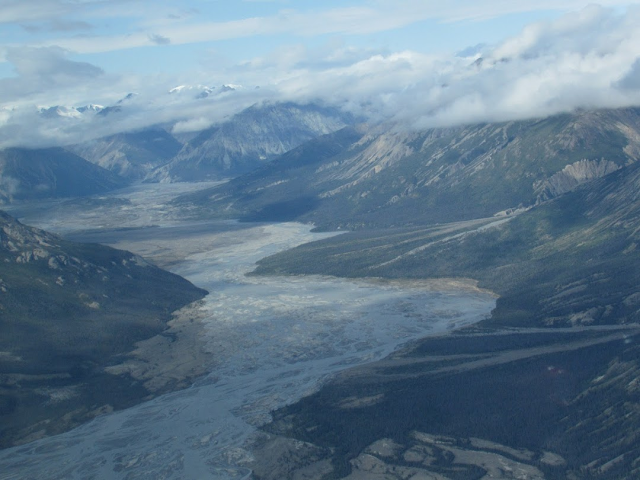


The views were breathtaking and with so much snow and ice to take in it was hard to know where to look next. Kluane has the largest non-polar ice fields in the world and it wasn't hard to see why that was true. Unfortunately, the clouds prevented us from getting a glimpse of Mt. Logan itself but we were close enough and others have taken the photo for us.

Mt. Logan
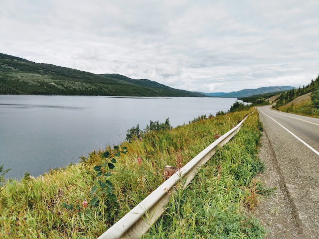
It was a tough act to follow and we drove to Whitehorse for the night marveling all the while at the beauty of Kluane and how undiscovered it was in comparison to other parks, particularly Denali in nearby Alaska. Saving Whitehorse for our return we headed off the next morning to Dawson City stopping to photograph the beautiful Lac LaBarge, the setting for Robert Service's famous poem The Cremation of Sam McGee.


Lac LaBarge is actually a part of the Yukon River which comes from the Gwich'in phrase meaning white water river. Starting just across the B.C. border in the glacier fed waters of Atlin Lake it flows for 3,190 kilometres through the Yukon and Alaska before emptying into the Bering Sea. The road to Dawson City, known as the Klondike Highway, roughly follows the Yukon River which is fed by other rivers that cross the highway including the Takhini, Big Salmon, Pelly, and Stewart and goes through miles of lush green forest.


The only other town between Whitehorse and Dawson is Carmacks, which also marks an important junction to the Robert Campbell Highway and is a marker for where the edge of Beringia extended.

Just past Carmacks is the famous Five Finger Rapids where paddle wheelers had to navigate a difficult stretch of water as they made their way back and forth between Whitehorse and Dawson. These sternwheelers/steamboats, as they were also known, continued operating until the 1950's when the Klondike Highway was completed and put them out of business.


At the viewing platform there are a steep set of stairs that take you down to the river's edge and along an interpretive trail to photograph up close the rapids themselves.


After the Pelly and Stewart crossings we arrived in Dawson City, the fabled capital of the Klondike gold rush of 1896-1899. The great piles of gravel tailings left over from the placer mining, and a blight on the landscape, were the first thing to greet us but we were soon in and amongst all the colourful buildings that have kept the town's heritage alive.


First stop of course was Bombay Peggy's, a converted whorehouse that is now one of Dawson's principal watering holes along with the Downtown Hotel.


The interesting fact about all these restored buildings is that for the most part they are all still in use by modern businesses.


Robert Service cabin


The last commercial steamboat to operate under its own power on the Yukon River was the Keno on August 29,1960 for the purpose of putting it on permanent display in Dawson City.


Of course Dawson City is all about the gold mining which is still active to this day and a visit to Dawson wouldn't be complete without a tour of the famous No. 4 Dredge.


The dredge's location in Bonanza Creek Road is just down the road from where Skookum Jim, Tagish Charlie, and George Carmack made the original gold discovery on August 17, 1896.


Driving along Bonanza road were markers to other historic claims and you could also watch modern claim stakers working their claims using the same technology as the old dredges and leaving behind the same kind of mess.


Decided to go for a drive on the Top Of The World Highway, an alternate route that connects Dawson City to the Alaska Highway and is only open for a few months of the year. First step was getting on the free ferry shuttle across the Yukon River. Once across the river the road climbs steeply and the mountainside seems to slip away very precariously on one side or the other. As you climb higher the trees disappear and you seem to be in the middle of the clouds. With the wind blowing it gets very cold, but there is a strange other world beauty to being up on these windswept hills where you really do feel you are on top of the world. At the closed border we turned back and took in a view of Dawson City from another angle.


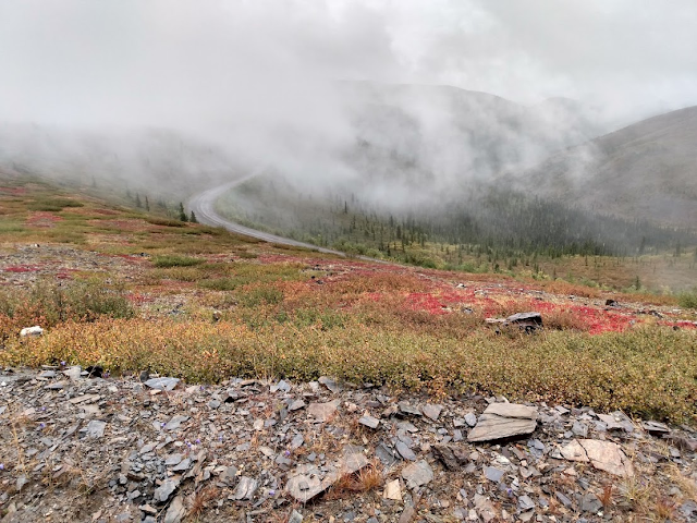


We were now ready to tackle the other main attraction of this trip and that was the infamous Dempster Highway. This is the 700 km. road that connects Dawson City with Inuvik in North West Territories that follows the old R.C.M.P. dogsled route, and took from 1958-1978 to complete. A dirt road built on top of 3-7 feet of gravel to protect the permafrost from melting, this is a road of uneven grading, potholes, and, when it rains, thick mud. Travellers should count on two days to make the journey and a spare tire is a must, but the scenery is spectacular.


The first place you come to is Tombstone Park and the Visitor Centre has a nice display and some information on the flora and fauna in the area and sells camping permits and maps but that's about all. If you need food, gas, or a place to stay you need to get to Eagle Plains or go back to Dawson City.


From this point onwards it becomes one overwhelming vista after another as you make your way past various rivers and tundra landscapes through the Ogilvie Mountains.


The bar had a colourful collection of historic photos and various stuffed animals from the area, and was a warm inviting refuge where everyone gathered to share stories and count their blessings if they didn't receive the Dempster gift of a free flat tire. It also offered hearty meals for the hungry and an opportunity to take stock for the next phase of the journey.


After a great night's sleep we were on our way the next day to complete the Dempster and our first stop was the Arctic Circle.


But, as we drove through the colourful tundra filled with tasty blueberries, who should we come across but a mother grizzly and her two cubs busily stuffing their faces with berries and not in the least concerned about us taking their picture.


The vast expanse of the colourful empty tundra reminded me of the African Serengeti for the reason it also performs a vital role in the annual migration of thousands of various ungulates. In this case it's the Porcupine Caribou herd, one of the largest migratory barren ground caribou herds in North America, numbering between 100,000-200,000 animals, that winters here.


The road just seems to go on forever but thanks again to Covid it was closed at Fort McPherson. We had already been to Inuvik and Tuktoyaktuk so having to turn back shortly after reaching the NWT border wasn't as much of a disappointment. Back to Eagle Plains to share more stories and get ready for the return journey which was much easier.


After congratulating ourselves on surviving the Dempster, and getting the Jeep all cleaned up, we enjoyed a celebratory dinner in Dawson City before heading back the next day to Whitehorse.

The largest city north of the 60th parallel, Whitehorse is the capital of Yukon and is located on the banks of the Yukon River. Named after the white horse rapids further upstream, it boasts a wide variety of cultural and recreational activities that make it a very attractive place to live or visit. One of the principal attractions is the Klondike the last steamboat in regular service to operate on the Yukon River.

It has some great museums like the MacBride Museum that explore the natural, social, and economic history of the region and my personal favourite the Beringia Interpretive Centre with its exhibits of life during the period 11,000-16,000 years ago when there was a land bridge between Asia and North America that allowed for humans to cross over along with animals like the steppe bison, sabre tooth cats, and wooly mammoths. Many of these fossils were found frozen in the permafrost around Dawson City by the miners working their claims.

McBride Museum


Whitehorse also has some colourful dining and drinking establishments that characterize the northern vibe in a unique way. Places like the Burnt Toast, Woodcutters, or the Capital Hotel with its Miner's Daughter restaurant and Dirty Northern Bastard bar.


They also have a nice selection of public art that pays tribute to the heritage of the north and some of its famous personalities.


On the outskirts of Whitehorse is the 700 acres Yukon Wildlife Preserve a unique facility providing a natural environment for 12 species of northern mammals including bison, moose, elk, bighorn sheep, mountain goats, muskox, caribou, deer, foxes, and lynx. It's also a research and rehabilitation centre where injured animals are treated. There were also some other strange animals wandering around that defied description but all in all it was a lovely place to spend time up close with the animals.


A visit to Whitehorse wouldn't be complete without a drive to Carcross where you can catch the White Pass & Yukon Railway to Skagway. Of course, with Covid this was closed as well but fortunately we had already enjoyed the train ride on a previous trip so we were free to just enjoy the town itself and some of the nearby scenery like the beautiful Emerald Lake.


The striking artwork of the Tagish/Tlingit people is evident as soon as you enter the community and continues from the welcome centre to the train station. The colourful buildings are filled with shops and artisan carvings but, unfortunately, without the train running there are few tourists or customers. The original discoverers of the Klondike gold, Skookum Jim, Tagish Charlie, and Kate Carmack were all Tagish people.


By the time the railroad was built the gold rush was over but it continued to be used to service the mining in the area and the railway company also had a fleet of steamships like the Tutshi that ferried freight and passengers around the Tagish and Bennett lakes and up and down the Yukon River.


Just outside of Carcross, once known as Caribou Crossing for the large herds of caribou that used to pass through here, is the Carcross Desert, which, at 640 acres, claims to be the smallest desert in the world.


The country is beautiful and rugged but the early settlers found ways of getting around and connecting the various waterways along with building a railway. Amazing what a little gold can do.


It's another uneven road that goes on forever while you are surrounded by imposing mountains, beautiful lakes, and lush forest.


The clouds and mist can be a bit intimidating, but when the sun comes out the beauty is once again overwhelming and after overnighting in Dease Lake we enjoyed a lovely drive the next day with the road conditions steadily improving. There were lots of bears along the way waving to the tourists and a particularly nice stop was at the Provincial campground and picnic area of Meziadin Lake.


Meziadin Lake
At the junction of Highways 37 and 16 where the Skeena River meets the village of Kitwanga/Gitwangak we could see the remains of the 108 year old Anglican church that had been burned to the ground a month earlier as part of the wave of protests over the recent residential school developments. Sadly, this was just the latest in a series of injustices the First Nations people have suffered and, as we drove down Highway 16, now known as the Highway of Tears, we could see the red dresses pinned on posts along the way marking where one of the more than 40 murdered or missing women, mostly First Nations, were discovered. Yet another sad chapter in our dealings with the Indigenous people of this country. All in all, very heartbreaking.


Thankfully at the end of every road there's a place to quench one's thirst.


Heading down Highway 97 past Quesnel, Williams Lake, and 100 Mile House to Cache Creek was more of the same as farms and the Fraser River dominated the landscape and the only animals were happy cows.


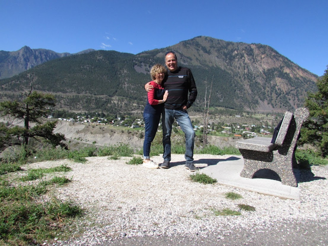
After Cache Creek the road gets a little dodgier all the way past Lillooet and into Pemberton but thankfully that was the last stop before home. But the stunning scenery never ends.


We put nearly 10,000 km. on our rented vehicle doing our return to Yukon trip over the course of nearly a month. Going up North requires a serious time commitment because the distances are so vast but, if you want to avoid the crowds and really get into nature, this is the place to go.


There are only two slots type games -P.Mang Vegas by Neowiz Playstudio andSlot Social Casino by Locojoy 토토사이트 - ranked between seventh and tenth within the casino class on the Korean Google Play retailer. No American-style social casino creating studios have been succeeded in Korea yet because of of} its stronger laws in slots. Crenova has not received any special authorized permission for the Korean business since we're not offering any companies to the Korean market in the intervening time.
ReplyDelete